Problem
A local company wanting to expand its customer base is in need of knowing where they should focus their efforts on advertising. Since many retail establishments keep customer data on file, this was a perfect way to use geocoding to determine the best area for them focus their advertising and marketing. Geocoding tabular data involves using location data in tabular form and connecting it to a location on the map.
Analysis Procedures
In order to analyze marketing potential for this retail establishment, customer data was provided in the form of an excel sheet and a customer database. This was geocoded with Wake County ZIP Code and street data, which provided a vector reference, along with a Wake County shape file. ArcMap, a program in the ArcGIS suite, was used to process and analyze the data.
Methods
The first step involved batch geocoding customer addresses based on ZIP Codes for Wake County using Address Locator in ArcMap. The second part of the problem required geocoding addresses to street data by setting up a dual range address locator. After locating several points on the map, all addresses were processed, some requiring to be rematched.
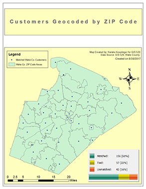
Results
The completion of this project resulted in two maps created for the retail establishment. Map 1 represents customer addresses based on zip codes, and Map 2 represents geocoding customer addresses to street data.
(Map 1- Customers matched with geocoding) (Map 2 - Geocoding by streets)
Application and Reflection
Geocoding tabular data is a great way to use various kinds of address identifiers and tie it to a location on the map. There are many uses for this kind of analysis in both private and public sectors. It's nearly impossible to patronize any retail establishment without giving a zip code or phone number. Similarly, Online retailers, such as Amazon, know what kind of items sell best in different geographic locations.


Copyright © 2018 pixelboro.com

